- A new video shows how experts train to identify human activity from space.
- Even amateurs can use freely available satellite imagery to discover new and fascinating things.
- Military bases, often designed with order and efficiency in mind, are particularly fun to watch.
A new video offers a fun introduction to a free activity that anyone can do: spy on countries and their armed forces from space.
Keith Masback, the former director of intelligence, surveillance, and reconnaissance integration for the U.S. Army and a veteran of the U.S. Geospatial Intelligence Foundation, recently showed WIRED how to use satellite imagery to peer down on any—yes, any—location on the planet. Here’s the video:
Here are a few tricks for identifying military bases and other seemingly secretive stuff in satellite imagery, which is available for free on sites like Google Maps and the U.S. Geologic Survey.
Spy trick #1: Look for straight lines.
Nature rarely, if ever, produces a straight line, Masback says, so if you see one in satellite imagery, that’s a good sign of human activity in the area.
Spy trick #2: Recognize rows.
Masback also suggests scanning images and paying attention to particularly neat and tidy rows, which often indicate the presence of military bases. Such organization is a product of military discipline and the practical need to keep track of dangerous equipment.
Spy trick #3: Scan the runways.
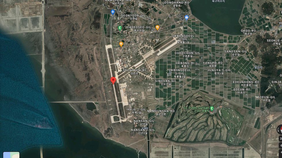
Military airfields are perhaps the easiest sites to locate. These airfields often have a smaller footprint than an international airport serving a major city, but have equally long—if not longe—runways. The runways are also doubled up in case one suffers battle damage.
The U.S. Air Force’s Kunsan Air Base in South Korea includes all the classical features of an air base, including hardened aircraft bunkers built in a chevron-like pattern at the south end of the runway.
Kunsan also features several nondescript, squarish buildings, which are munitions bunkers designed to offer protection to bombs and missiles while containing an explosion if a fire detonates the weapons stored inside.
Spy trick #4: Watch the waters.
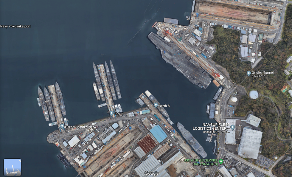
Naval bases are also fairly easy to spot—just look for a harbor or port with long, slender hulls (or aircraft carriers). The U.S.-Japanese naval base at Yokosuka, Japan is one prominent example, with the aircraft carrier USS Ronald Reagan easily identifiable (her hull number, 76, is visible on the forward flight deck) while the other large ship nearby is the command ship USS Blue Ridge. You can also see U.S. and Japanese destroyers.
Two Japanese Maritime Self Defense Force submarines are to the southwest. One submarine has a visible tail fin lined up with the hull, making it an Oyashio-class sub with a traditional cruciform tail. The other sub shows two shorter tail fins, making it a Soryu-class sub with an X-shaped tail.
Spy trick #5: Pick out the parking lots.
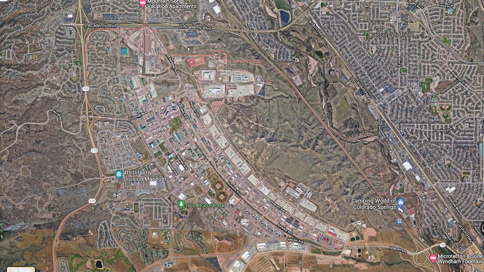
Want to find army bases? Take Fort Carson, Colorado, home of the U.S. Army’s 4th Infantry Division, for example. Army bases tend to look like self-contained communities, which they are, with plenty of apartment complex-style housing, unusually large vehicles parked in orderly rows, and small airports for helicopters and fixed-wing planes.
There’s usually a large, brown area on the base grounds that looks like it’s been churned over many times by tracked armored vehicles.
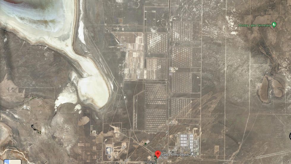
Above, you’ll see an extreme example of the Army base as a parking lot: Sierra Army Depot in Northern California’s Lassen County. Sierra is where the Army parks obsolete or otherwise unneeded armored vehicles, including M1 Abrams and M2 Bradley fighting vehicles, in nearly endless rows of hundreds of vehicles. The base is also where the Air Force exiled the plans and dies for manufacturing the F-22 Raptor fighter jet after production ceased in 2011.
🎥 Now Watch This:

Kyle Mizokami is a writer on defense and security issues and has been at Popular Mechanics since 2015. If it involves explosions or projectiles, he's generally in favor of it. Kyle’s articles have appeared at The Daily Beast, U.S. Naval Institute News, The Diplomat, Foreign Policy, Combat Aircraft Monthly, VICE News, and others. He lives in San Francisco.

