Route Editor

| Guide | ♦ | 8 Triplogs | 1 Topic |
details | drive | permit | forecast | route |
stats |
photos | triplogs | topic | location |
| 46 | 8 | 1 |
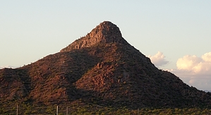
Giza Shmeeza by Barrett Familiar to anyone who has traveled along I-17 between the 101 and 303 and bothered to look out their side window, Pyramid Peak is aptly named. Its dimensions are almost identical to the iconic Great Pyramid at Giza (756' tall, 51-degree slope) with a hike elevation gain of 770' and possible gulley routes with slopes in the 50-degree range. Located at the southern end of Biscuit Flat and cut off from development on the south by the CAP canal, it resides on a section of State Trust Land that used to be a favorite among ATV users but now prohibits motorized travel. As a result, the area is now incredibly quiet but has a dizzying network of double and singletrack well suited for both mountain biking and hiking. From a geologic standpoint, it's similar to the north end of the McDowell Mountains, comprised of Porphyritic granite weathered into spheroidal boulders that allow it to maintain a much steeper slope than the basaltic lava summits typical of northern Phoenix. The integrity of the granite varies widely, with some areas providing rock-solid holds and killer traction, and others easily fractured and covered with slippery grus (the granular fragments of decomposed stone, usually from granite in arid environments).
Fauna is also on the thin side, which seems surprising given the CAP canal's proximity as a water source and the number of small pools that hold water after rain, particularly to the east of Pyramid. Access to the peak is made reasonably convenient by parking in the Deem Hills Park lot and walking west along N Deem Hills Pkwy, then turning north along W Deem Hills Pkwy, which soon veers northwest before hitting 51st Ave. Turn right and head north, which will take you to "Road Closed" signs and the CAP canal bridge. Progress beyond this point, which the signs will remind you, requires a State Trust Land Permit, which of course you now have in your pocket. Follow the sandy N Pyramid Peak Transmission Line road north and decide which route is to your liking. You can ascend the pyramid from almost any direction, and the roads in the area will lead you pretty much anywhere you want to go. Just keep your horizon landmarks/compass/GPS handy, and you should be fine. For guide, I'll describe the Northern Approach, as I feel it's the easiest/safest. After crossing the canal, you will see several smaller rock outcroppings to your left between you and Pyramid, and you want to get around these on their north side. Continue north under the power lines until you see a diagonal, well worn two-track leading northwest that will point basically to the base of Pyramid - take it. From here, you will pass numerous intersections, but keep choosing the one that heads in the direction of Pyramids north slope, and you will get there. As you approach the northeast corner, you will see a small outcropping on your left, and this is where you will leave the road and begin your off-trail ascent. Proceed uphill toward the rocky section visible about 3/4 of the way up, and shoot for the gully between the two largest outcrops. Honestly, if you keep scrambling uphill, there is no wrong way. As you approach the top, it will become almost completely granite boulder hopping as you reach the north lower summit. From here, you drop down and head into the big cleft boulder, a great place to hang out that is sheltered from the sun and wind. Continuing upward and to the south will take you to the actual summit, where you will find a summit register and tasty 360-degree views. Topos show a 2269' VABM, but I have dug around the entire summit area and found none. I assume it's buried more than a few inches or stolen at this point, but knock your socks off. From here, I would recommend returning along the same path - I've summited along 5 different routes, but all of them I would recommend going up first before attempting a down climb. The southeast face is vertical rotten stone I wouldn't even rappel, and the south face, in general, is very steep with an exposure that might not be lethal but could entirely ruin your day if not more. Both the east and west slopes have a gulley that makes for a steep, loose, but direct ascent. Like all off-trail adventures, experience and good judgment, along with gloves and an essential daypack, should be all you need. The steep terrain and sometimes wobbly boulders will challenge your sense of balance. I prefer long pants, gaiters, and long sleeves, but the brush, particularly along this route, is not too bad, and you might be comfortable with less. Access to water depends on seasonal rains, which will create pools near the eastern base of Pyramid. These become quite nasty as they bloom and churn out mosquitos. CAP canal access is illegal, but in a life-or-death situation, it is always on the table, though if you make it to the canal, houses are only a few hundred yards away at that point. Depending on the time of day, entire ascents and descents can be done in the shade of this fairly steep landmark, along with shade found amongst the boulder outcroppings to the southeast - the rest of the approach is full sun. So if you love beating the crowds, off-trail scrambling, weathered spheroidal granite, and cool, solitary summits (but could do without Catclaw and Cholla), Pyramid might be the peak for you. Check out the Official Route and Triplogs. Leave No Trace and +Add a Triplog after your hike to support this local community. | ||||||||||||||||||||||||||||||||||||||||||||||||||||||||||||||||||||||||||||||||||||||