Route Editor

| Guide | ♦ | 11 Triplogs | 3 Topics |
details | drive | permit | forecast | route |
stats |
photos | triplogs | topics | location |
| 119 | 11 | 3 |
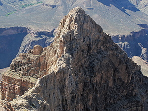
rediscover life by joebartels Overview An excellent day hike from the South Rim in Oct/Nov or Mar/Apr. This thrilling needle of a summit pronounced key-ops sits as the tail for the southern terminus of Cheops Plateau. Avid off-trail hikers should be able to tackle this sweet adventure. Warning While the risk factor is minimal, a capable partner is a wise choice. Contouring the loose angled slopes may use stabilizer muscles you are not used to using regularly.
Regardless of your approach, you will need to understand the Utah Flats Route. As such, most will be coming from BA Campgrounds. This is where the Utah Flats Route begins, precisely 7 miles from the South Rim via SK. It's another 1.9 miles to the turnoff for Cheops Pyramid. Perhaps more if you are not familiar with the UFR and zig-zag a bunch. Off-Trail While the UFR is not an official trail, it is a worn use-trail. Turning off for the Pyramid puts you out into the true wild. The route to the south end of the Pyramid is arbitrary. I know of one group that has traversed the west side of Cheops Plateau after summiting the plateau. I suggest the posted official route (the lowest possible route) for a couple reasons. While it is longer, it travels much faster than higher up the slopes. It also seemed to have fewer nervous moments along the way. I spent more time enjoying the views than staring at my feet too. Southern Ramp I read, was told, or somehow was under the impression the south ascent up to the pyramid was a walk-up ramp. That isn't the case, yet it's nothing difficult either. Just fun tiered climbing up easy short levels with mostly good handholds. The sandpaper tarter speckled rock makes gloves a worthy choice. The summit isn't a grueling conquer. Yet, I was blown away by the feeling of standing atop such a prominent needle. Once the feeling sets in, you realize you might be witnessing the best 360-degree views on earth. Looking back at the plateau is especially cool if you have recently conquered that beast. This isn't a technically challenging hike. Yet everything compounded together will probably leave you mighty fatigued. Especially if you started and ended your day in Phoenix, Arizona, with the plateau on route. Water Typically none after leaving BA CG. You might find a little soon after leaving UFR. Stats
Check out the Official Route and Triplogs. Leave No Trace and +Add a Triplog after your hike to support this local community. | ||||||||||||||||||||||||||||||||||||||||||||||||||||||||||||||||||||||||||||||||||||||||||||||||||||||||||||||||||||||||||||||||||||||||||||||||||||||||||||||||||||||||||||||||||||||