Colombia
Presidential republic
Official:
Republic of Colombia
Local name:
Colombia
Region:
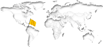
South America
Surface area:
1,141,749 km²
Capital:
Bogota
Geography
Colombia is a country in northernmost South America with access to the Pacific and the Caribbean. The land has a total area of 1,141,749 km² (440,831 mi²) and a total coastline of 3,208 km (1,993.4 mi). This land area is approximately 164% of the area of Texas. Colombia is thus one of the largest countries in the Americas and the 26th biggest in the world. An exceptionally high proportion of residents (82%) belongs to the urban population. Every seventh resident lives in Bogota alone.Colombia lies at an average elevation of 593 meters above sea level. The highest mountain peak (Pico Cristóbal Colón) is at 5,775 meters. The country has about 270 partially uninhabited islands. There are direct national borders with the five neighboring countries Brazil, Ecuador, Panama, Peru and Venezuela. The distance between New York City and the Capital Bogota is about 4,020 km (2,498 mi).
On further pages:
Current time in Colombia:
The countrywide time in Colombia is Colombia Time (COT), which is currently 1 hours behind New York.
As in many countries, there is no daylight savings time in Colombia.
Related to Greenwich Mean Time, there's the same difference of -5 hours all over the year.
Public Holidays in ColombiaSunrise + Sunset00:00
May 2024
The countrywide time in Colombia is Colombia Time (COT), which is currently 1 hours behind New York.
As in many countries, there is no daylight savings time in Colombia.
Related to Greenwich Mean Time, there's the same difference of -5 hours all over the year.
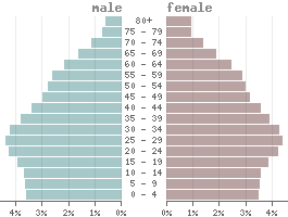
Population
Population:51,874,000
Population per km²:45.43
Life expectancy males:Ø 69.4 years
Life expectancy females:
Ø 76.4 yearsBirth rate:
14.2 ‰Death rate:
7.7 ‰Males/Females:
49.3% : 50.7%Population pyramid
The currency in Colombia is the Colombian peso (COP).
1 Peso is divided into 100 Centavos.
Status: 05/10/2024
1 Peso is divided into 100 Centavos.
Status: 05/10/2024
1 US dollar = 3,889.59 Pesos
10.000 Pesos = 2.57 US dollar
10.000 Pesos = 2.57 US dollar
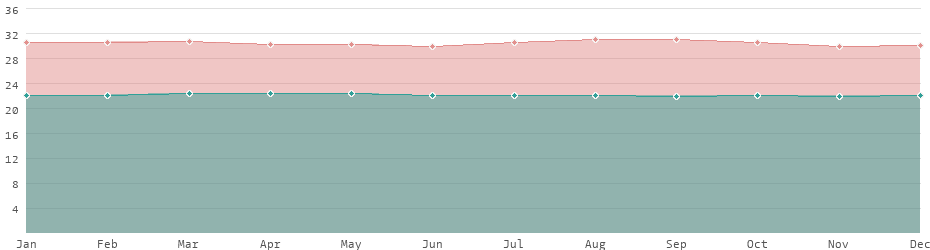
Climate in Colombia
The climate in Colombia is extremely diverse due to the varied topography. Located on the equator, the climate is predominantly tropical with constant temperatures throughout the year. There are hardly any seasonal temperature differences. Temperatures are cooler in the Andean region, while warmer in the coastal regions. The Amazon region is considered particularly rainy. In contrast, the Caribbean coast is rather dry. The country is mainly characterized by its two rainy seasons in April/May and October/November.Average daytime and nighttime temperatures
Languages
Official language:
Spanish
| Mother tongue | Distribution |
|---|---|
| Spanish | 99.0 % |
| Arawakan | 0.1 % |
| English Creole | 0.1 % |
| Quechua | 0.1 % |
| other | 0.7 % |
more...
Economy
| GDP: | 343.62 bn $ |
| Exportations: | 73.11 bn $ |
| Importations: | 89.54 bn $ |
| › Tourism receipts: | 2.94 bn $ |
| Debt rate: | 63.63 % |
| › Unemployment rate: | 10.73 % |
| › Inflation rate: | 10.18 % |
| › Corruption index: | 40 (bad) |
| › Energy consumption: | 69.9 bn kWh |
According to the definition from the International Monetary Fund (IMF), Colombia is a developing country because of its lower economic performance.
With an average annual income of 6,500 USD Colombia is one of the upper middle-income countries.
Colombia is considered one of the most dangerous countries worldwide.
Land use
| 3% Urban areas: | 36,132 km² |
| 40% Agricultural areas: | 459,668 km² |
| 53% Forest: | 608,666 km² |
| 3% Water areas: | 32,249 km² |
| 3% Others: | 37,282 km² |
more...
Transport
| Roadways: | 206,102 km |
| Railways: | 2,141 km |
| Waterways: | 24,725 km |
| Reg. vehicles: | 15,000,000 |
| › Airports: |
Most important cities
Population refers to the city proper, not metropolitan areas.
| City | Greater Region | Population |
|---|---|---|
| Bogota / Capital | Andes | 7,181,000 |
| Medellín | Andes | 2,372,000 |
| Cali | Pacific Coast | 1,823,000 |
| Barranquilla | Caribbean Coast | 1,120,000 |
| Cartagena | Caribbean Coast | 888,000 |
| Soacha | Andes | 645,000 |
| Cúcuta | Andes | 629,000 |
| Soledad | Caribbean Coast | 536,000 |
| Bucaramanga | Andes | 529,000 |
| Ibagué | Andes | 501,000 |
| Bello | Andes | 482,000 |
| Santa Marta | Caribbean Coast | 480,000 |
| Valledupar | Caribbean Coast | 459,000 |
| Villavicencio | Orinoco | 451,000 |
| Montería | Caribbean Coast | 434,000 |
| Pereira | Andes | 410,000 |
| Manizales | Andes | 400,000 |
| Pasto | Pacific Coast | 352,000 |
| Neiva | Andes | 315,000 |
| Palmira | Pacific Coast | 303,000 |
| Popayán | Pacific Coast | 277,000 |
| Armenia | Andes | 276,000 |
| Sincelejo | Caribbean Coast | 275,000 |
| Florencia | Amazonia | 157,000 |
The difference between the urban area and the city proper alone can be considerable. Antioquia, for example, has an urban population of 101,000. However, the actual proper city is much smaller with only 25,000 inhabitants. The difference to metropolitan regions, i.e. conurbations with several cities, is even greater.
Political indicators
(Based on the "Worldwide Governance Indicators" project of the World Bank)
| Political stability: | ◈ |
| Rule of law: | ◈ |
| Effectivity: | ◈ |
| Regulatory quality: | ◈ |
| Voice accountability: | ◈ |
| Democratic values: | ◈ |
| Death penalty: | abolished in 1910 |
 Country comparison: Colombia / India
 Ecuador: country data and statistics
 List of 152 developing countries